Aerial views of areas hard hit by Typhoon Haiyan show the extent of the destruction across the central Philippines, where emergency management officials say they fear as many as 10,000 people died just in the city of Tacloban in one of the most powerful storms recorded.
As my colleagues, Keith Bradsher and Gerry Mullany reported, relief efforts have been complicated by the magnitude of the devastation. Impassable roads, downed power lines and toppled cellular towers have made it difficult to reach survivors in need of food and water.
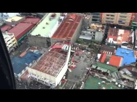
A view of Tacloban, shot by Erel Cabatbat of TV 5 in the Philippines, shows the impact of the tsnuami-like storm surge on this city of about 223,000, the capital of the Philippine province of Leyte.
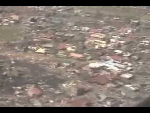
Because of downed communication lines, national disaster officials were unable to determine the loss of life and assess the full impact of the storm in some parts of the eastern Visayas, including Guiuan. Aerial video and images from the Central Command of the Armed Forces for the Philippines on Sunday showed the extent of the damage for the first time since the storm struck on Friday.
On Facebook, Col. John Sanchez of the Central Command, AFP, shared multiple aerial videos and photos and wrote that 100 percent of the structures in Guiuan were damaged.
Guiuan bore the brunt of Super Typhoon Yolanda at its first landfall last Friday. One hundred percent of the structures either had their roofs blown away or sustained major damage. Nearly all coconut trees fell. We saw people in the streets, seemingly dazed. Trucks and cars were left in the streets where they were stopped in their tracks as Yolanda struck. We were probably the first outsiders to fly over the area since Friday and obviously, no relief goods have arrived there yet. It was almost lunchtime but there was no smoke from cooking fires. The 2.4 km. runway is clear of debris and could still be used by C130 aircraft. Yolanda is probably worse than Pablo and the only reason why we have no reports of casualties up to now is that communications systems in Region 8 are down…
- Col John Sanchez
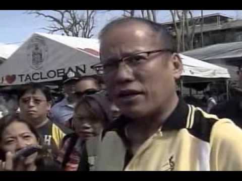
Another aerial view of Tacloban from the YouTube channel of President Benigno S. Aquino III, captured as the president arrived to meet with local officials show the impact of the storm surge that officials said reached 13 feet when it pushed into the city.
Speaking to reporters after touring the devastation in Tacloban, President Aquino said the number of those feared dead was alarming but still “subject to verification.†He said local officials were designating areas for mass burials.
“The priority has to be take care of the people who are alive,†he said. “The priority has to be food, the restoration of water and power and communications.â€
While the aerial views show the storm’s wide swath of destruction, the most horrifying images surfacing on social media are from the ground, where dead bodies can be seen lying on streets and among shattered buildings and debris.
Jim Edds, a photographer and videographer for Extreme Storms.com, was in Tacloban when the storm struck. On Sunday, he shared multiple photographs on his Twitter account, @ExtremeStorms, of the devastation that he saw in the city, including a photo of a school, where he said a man, cradling a dead child, told him 10 children had been killed.
Official updates from the government say that nearly 10 million people were affected by the storm.