.nytVideo, .nytVideo video, .youtubeVideo, .youtubeVideo iframe { background: none repeat scroll 0 0 #000000; } .youtubeVideo { position: relative; } .youtubeVideo, .youtubeVideo .thumb { height: 0; padding-bottom: 56.25%; } .youtubeVideo iframe { height: 100%; left: 0; position: absolute; top: 0; width: 100%; z-index: 1; } .youtubeVideo .playButton { border-radius: 10px 10px 10px 10px; height: 46px; left: 50%; margin: -23px 0 0 -35px; position: absolute; top: 50%; width: 70px; z-index: 2; background-image: -webkit-linear-gradient(90deg, #6e0610, #ff0000); /* Safari 5.1+, Mobile Safari, Chrome 10+ */ background-image: -moz-linear-gradient(90deg, #6e0610, #ff0000); /* Firefox 3.6+ */ background-image: -ms-linear-gradient(90deg, #6e0610, #ff0000); /* IE 10+ */ background-image: -o-linear-gradient(90deg, #6e0610, #ff0000); /* Opera 11.10+ */ } .youtubeVideo .thumb { overflow: hidden; width: 100%; } .youtubeVideo .thumb img { height: auto; width: 100%; margin-top:-45px; } .youtubeVideo:hover .thumb { cursor: pointer; } .youtubeVideo:hover .playButton { } .youtubeVideo .playButton .arrow { border-bottom: 10px solid transparent; border-left: 20px solid #FFFFFF; border-top: 10px solid transparent; height: 0; left: 28px; position: absolute; top: 13px; width: 0; } .clearfix:after { clear: both; content: "."; display: block; height: 0; visibility: hidden; }
The National Oceanic and Atmospheric Administration issued its 2013 Atlantic hurricane outlook on Thursday, with a warning that the United States could be hit by up to six major hurricanes this year. The seasonal average is three.
Oceanic and atmospheric conditions in the Atlantic basin are expected to create stronger and more hurricanes, setting the stage for an “above normal and extremely active†season, said Gerry Bell, lead seasonal hurricane forecaster for NOAA's Climate Prediction Center, who explained the underlying reasons in a NOAA video.
“These conditions include weaker wind shear, warmer Atlantic waters and conducive winds patterns coming from Africa,†Mr. Bell said.
Specifically, Mr. Bell predicted that 13 to 20 named storms would form in the Atlantic this year, compared with the usual 12.
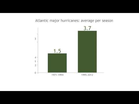
Of those, seven to 11 storms could become hurricanes, with wind speeds of at least 74 miles per hour, a range that is well above the seasonal average of six.
And three to six of those storms could become major hurricanes with winds of up to 111 miles per hour, compared with the seasonal average of three.
NOAA cited three climate factors that are expected to come together to produce an active or extremely active 2013 hurricane season:
A continuation of the atmospheric climate pattern, which includes a strong west African monsoon, that is responsible for the ongoing era of high activity for Atlantic hurricanes that began in 1995; warmer-than-average water temperatures in the tropical Atlantic Ocean and Caribbean Sea; and El Niño is not expected to develop and suppress hurricane formation.
These predictions are similar to those outlined this month by researchers from Penn State University's Earth System Science Center, as well as AccuWeather and other forecasters.
“With the devastation of Sandy fresh in our minds and another active season predicted, everyone at NOAA is committed to providing life-saving forecasts in the face of these storms and ensuring that Americans are prepared and ready ahead of time,†said Kathryn D. Sullivan, the acting NOAA administrator.
 NASA, via Getty Images A satellite image of Hurricane Sandy on Oct. 28, 2012, from the National Oceanic and Atmospheric Administration.
Last week, NOAA made public its assessment of its own performance during Hurricane Sandy, which which killed more than 100 people and caused more than $50 billion in estimated damages.
Over all, NOAA concluded that it “performed well in forecasting the impacts of this extremely large storm.†It noted, for example, that it issued warnings well in advance about the potential for dangerous winds and storm surge inundation of four to eight feet above ground level for the New Jersey, New York and Connecticut coastlines.
But the agency acknowledged that it needed to do a better job of communicating its forecasts - particularly the storm surge forecasts - to emergency managers and the public.
Officials in Mayor Michael R. Bloomberg's administration said they did not evacuate nursing homes and disabled residents from low-lying areas of New York City in the days leading up to the storm because of their understanding of the storm surge forecasts.
“The highest priority need identified by NOAA/NWS customers and constituents is for improved high-resolution storm surge forecasting and communication,†the report said, referring to NOAA and the National Weather Service. “In particular, there is a crucial need for storm surge graphical inundation guidance.â€
The report added that “79 percent of coastal residents surveyed in March 2013 said the impact of Sandy's surge in their area was ‘more than they expected.' â€